peterhead elements
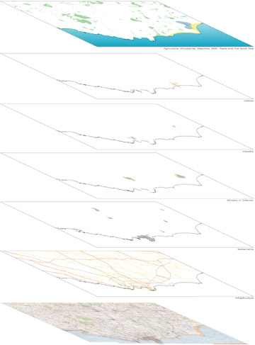
It is necessary to understand fully the various layers present in the landscape prior to making any design proposals.
In the diagram to the left various information has been extrapolated from the composite map of the area.
The different layers from bottom towards the top represent infrastructure (roads, powerlines), settelement patterns, Ministry of Defence airfields (past and present), areas where there is industrial activity, utilities (notably St.Fergus Gas Terminal), and on top natural features: Loch Strathbeg (nature reserve), sand dune areas to the north of Peterhead and vegetational patterns.
All interventions one may decide to propose are bound to have an effect on one or more of said components in the landscape. Consequently, it is necessary to reckognize their presence and fully understand how they interact.